
Athens Tower of Winds Opens to Public
 In the old Roman Agora on the slope of Athen's ancient Acropolis hill is the Tower ofWinds. Today, completing two years of restoration, the interior was re-opened to the public this summer in August, 2016. The Tower had been closed for the last 200 years. The story of the Tower starts in the first century, BCE, probably during the reign of Julius Caesar.
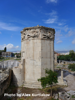
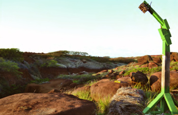
The Tower was designed by Andronikos Kyrrhestos (Andronicus of Cyrrhus), an astronomer and maker of celestial instruments. Andronicus constructed a white marble sundial for the sanctuary of Poseidon and Amphitrite on the island of Tinos. The sundial becamse so famous that Andronicus was invited to Athens where he erected the magnificent 14 meter Tower called the Aerides (the Winds) . It was built on the eastern side of the Roman Agora in Athens and meant to have utilitarian value. "No one knows who funded its lavish construction - the octagonal monument is made almost entirely of Pentelic marble, the same used for the Parthenon and rarely found in buildings other than temples," said Stelios Daskalakis, head conservator.
Atop of the octogon tower now rests the fully-preserved roof made of 24 marble slabs, resting on a Corinthian capital. Once a bronze statue of Trition, the god of the sea, was set on the roof to turn in the wind as a weather indicator. By night, water flowed through a hydro-mechanical system designed by Andronicus from a cylinder inside the Tower. The water level lead to an exterior indicator creating a night time clock or clepsydra. During the day the Tower was a public time teller with eight sundials.
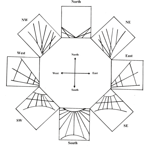
On each octogon wall of the Tower is a winged figure carved in relief, in total representing the eight Anemoi - the eight gods of wind in Greek mythology (Boreas, Sciron, Zephyr, Lips, Notos, Euros, Apeliotes, and Caecias). Beneath each frieze is a sundial. The shadow was cast by a horizontal gnomon and today the hour lines appear faint, but still visible. Theodossiou, et. al. have drawn each of these sundials:
 The Tower had been half-buried by material accretion over the centuries. In the early Christian period the Tower was converted into a baptismal chapel (with surviving traces of angelic frescos on the wall) and the area outside the north east entrance was a Christian cemetery. In the 14th century, Kyriacus of Ancona mentions the Tower as a temple of Aeolus, while an anonymous traveler refered to it as a church. In the 18th century under Ottoman rule, the Tower was used as a place of worship by the Sufi Muslim Whirling Dervishes, with a mihrab niche carved in the wall to point to Mecca. The Tower was used by the Dervishes as a smoking room. "In 1799 [Lord Elgin] began planning the transfer of the entire monument to Britain. But it was considered a sacred place and [the Muslims] did not allow the monument to be uprooted," said Daskalakis.
The Tower of Winds was excavated in 1837 and 1845 by the Greek Archaeological Society. Restoration work was carried out between 1916-1919 by the late professor of Byzantine Studies, Anastasio Orlandos, and in 1976 by the First Ephorate of Antiquities. The most recent restoration, begun in 2014 by the Athens Ephorate of Antiquities, is lead by Stelios Daskalakis and now the Tower interior is open to the public.
This article is the result of a Reuters announcement of the Tower's opening by Korlina Tagaris and Phoebe Fronista: http://www.reuters.com/article/us-greece-archaeology-towerofwinds-idUSKCN1101OS and http://www.ekathimerini.com/211470/article/ekathimerini/life/ancient-greeces-restored-tower-of-winds-keeps-its-secrets with detailed information from the North American Sundial Society article "The Tower of The Winds In Athens - The water clock and its eight vertical sundials", by Efstratios Theodossiou, Vassilios N. Manimanis, and Petros Mantarakis, NASS Compendium Vol. 13 Nr. 4 Dec 2006.
Additional reading: https://en.wikipedia.org/wiki/Tower_of_the_Winds Drawing of the sunidals from Theodossiou, et. al. and photo of the Tower of Winds from Alex Kurtiakov
- Details
- Hits: 23754
Antioch Mosaic Sundial
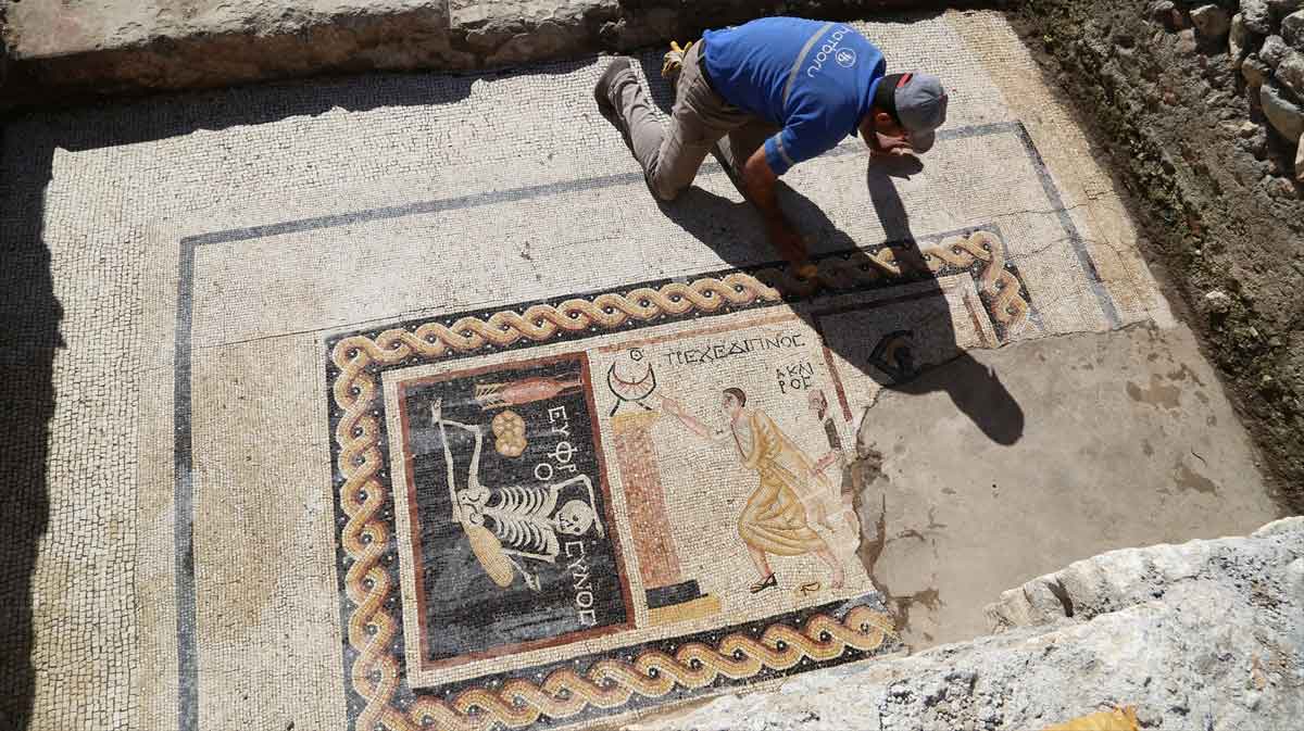 Mosaic at Antioch - by permission Daily SabahThe Daily Sabah reports a 2,400 year old mosaic discovered during excavations in Turkey's southern Hatay provice that shows a skeleton that according to archeologist Demet Kara fromthe Hatay Archeology Museum has an inscription that translates from ancient Greek to say "Be cherrful, and live your life."
Perhaps more interesting to sundialists is the mosaic further right. It is of a Roman attending the bath. Demet Kara explains, "...there is a sundial and a young clothed man run[s] towards it with a bare-headed butler behind. The sundial is between 9 and 10 am. 9am is the bath time in the Roman period. He has to arrive at supper at 10am. Unless he can, it is not well received. There is writing on the scene that reads he is late for supper and writing about time on the other."
Kara added, "[This is] a unique mosaic in Turkey. There is a similar mosaic in Italy but this one is much more comprehensive. It is important for the fact that it dates back to the third century BCE...Antiocheia was a very important, rich city. There were mosaic schools and mints in the city. The ancient city of Zeugma in [the southeastern province of] Gaziantep might have been established by people who were trained here. Antiocheia mosaics are world famous."
- Details
- Hits: 25494
Kanaloa Stone Endangered
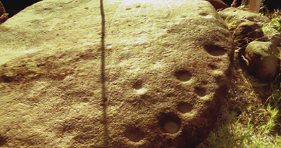 Kanaloa Stone with Stick Casting ShadowsOn Kaho'olawe, the smallest island of the Hawaiian island chain only 7 miles from Maui, sits an endangered and sacred rock, the Kānaloa, with petroglyphs and a row of 32 cupules (man-made depressions) along one edge. “It has significant celestial alignments with the rising and setting of the sun,” said Michael Naho'opi'i, Executive Director of the Kaho'olawe Island Reserve Commission (KIRC). It appears that there is a relationship between the shadow of a stick held vertically along lines etched in the stone and the cupules.
Documented as Site 110 feature BU, the Kānaloa stone is relatively flat and rests on a natural pedestal that when tapped, resonates with a bell-like ring. But its petroglyphs and alignment cups may soon topple into a nearby and ever growing ravine. In 2010 the Commission approved "The Cultural Use Plan: Kūkulu Ke Ea A Kānaloa" with one of the recommendations to preserve and stabilize the stone. The first phase of the plan has been to document the stone's celestial alignments and quantify the erosion forces acting on its base.
For native Hawaiians, Kaho'olawe is a sacred island, deeply rooted in history, culture, and religion. Called “Kānaloa” or “Kohemalamalama” in ancient times, the island has been inhabited since the 5th century AD. But it has had an uneven history: its population was devastated by competing chiefs, the island was turned into a prison colony by Kamehameha III in 1853, and for 50 years the island was used as a gunnery and bombing range starting in the 1920's. Native Hawaiians have pressed for the return of the island ever since they were ordered off in 1941.
 Kanaloa Stone Time Lapse Photography Photo:Kaho'olawe Island Reserve CommissionIn 1953 President Eisenhower promised to return the island to Hawaiians as soon as soon as its military usefulness ended, but it took nine protesters in 1976 to actually lay the groundwork for legal restoration. In 1981 the island of Kaho'olawe was placed on the National Register of Historic Places and a decade later in 1993, the U.S. Government approved a $400 million clean-up fund for Kaho'olawe, and in 1994 the island was officially returned to Hawaii with bombing permanently prohibited. Now the entire island and its waters can only be used for Native Hawaiian cultural, spiritual and subsistence purposes; fishing; environmental restoration; historic preservation; and education. Michael Naho'opi'i explains that “One of our traditional practices is to call the sun to rise in the morning to start our day.”
http://khon2.com/2014/11/17/exploring-kahoolawe-historic-and-cultural-landmarks/
Read more about Kaho'olawe Island Reserve Commission and island archaeology at:
- Details
- Hits: 16799
New Insights into Ancient Sundials
Larisa N. Vodolazhskaya of the Department of Space Physics at Southern Federal University (SFU), Rostov, has brought two ancient time keepers together with a new and startling result. The story starts at the turn of the end of the 19th century with the discovery of an L-shaped bar found in the tomb of Thutmose III (1479-1425 BCE). that appeared to be a sundial. In the 1930's a "user manual" of sort was found carved on the tomb ceiling of Seti I (1290-1279 BCE) at Abydos. The ideal L-shaped bar had lines engraved with distances from a starting mark of 3, 6, 9, and 12 units. The Seti I text describes these spacings as "an established procedure". But what is the procedure?
Then in March 2013 during the excavation of rubble associated with worker huts of Ramesses II (1279-1213) in the Valley of the Kings, Professor Dr. Susanne Bickel and her student archeological team from the University of Basel found one of the oldest sundials in the world. It is a vertical dial of limestone with what appear to be crudely drawn hour lines. The Basel team found a poor fit using hour lines with15o spacing expected of a traditional “unequal hour” sundial with horizontal gnomon.
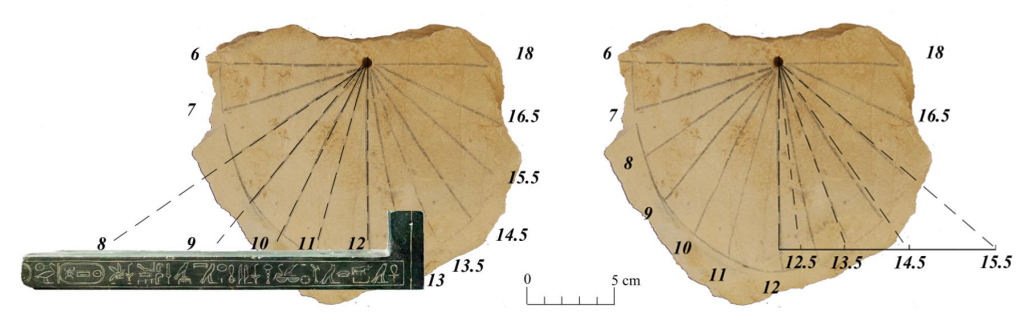 Dr. Vodolazhskaya of Department of Space Physics at Southern Federal University (SFU), Rostov, shows relation between tradition L-shaped Egyptian solar indicators and Egyptian vertical dial discovered in the Valley of the Kings by the University of Basel in March 2013Dr. Vodolazhskaya analyzes the use of these two sundial objects together, showing that the Valley of the King dial has accurately drawn hour lines that can be constructed by the L-shaped bar. The simple spacing distances of marks on the bar (ideally 1, 3, 6, 9 and 12) are measured for two L-shaped solar indicators held in the Berlin Museum. The ratios are close to ideal, but not exact. Vodolazhskaya argues that these differences of L-shaped solar markings are intentional: one for marking (or interpreting) the morning hours of a vertical dial, and another for marking the afternoon hours where the lines are offset by half an hour. Vodolazhskaya speculates,"we associate the half-hour shift in the markup with the need for ...midday rest for workers - the traditional siesta ..."
Dr Vodolazhskaya shows that Egyptian time telling was far more advanced than previously credited, but done in such a way that only the cognoscenti, the priesthood who held the L-shaped bar, could draw the lines of a sundial to create sundials with astounding accuracy of time. Her analysis is significant, showing that the Valley of the King dial using "equal hours" implies a gnomon pointed to the north celestial pole. This Egyptian feat would not be replicated again for nearly 3000 years until the Arab Ibn al Shatir constructed the first "modern" sundial at the Great Mosque in Damascus in 1371 CE.
Read more: http://arxiv.org/ftp/arxiv/papers/1408/1408.0987.pdf
- Details
- Hits: 17818
al-Biruni's Cosmos
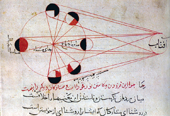 Al-Biruni's diagram of the moon's phases. Credit: photo reproduction from Seyyed Hossein Nasr, Islamic Social Science: An Illustrated Study (World of Islam Festival Publishing Co., 1976) Photo use for non-profit educational purposes only.Ibn al-Shatir, whom we give credit for inventing the first modern sundial with gnomon pointing to the celestial pole in 1371 C.E., is but one of many scientific scholars of Central Asia during the “Eastern Renaissance” that lasted from about 800 to 1500 C.E. In this week’s issue of Science, [20 June 2014] Richard Stone reviews the accomplishments of Abu Rayhan al-Biruni (born 973 C.E.) and the possibility that he "discovered" the American continent.
Situated at the crossroads of cultures from China, India, the Middle East, and Europe, al-Biruni was an acomplished astronomer at an early age. At 16 he measured the height of the midday sun and calculated the latitude of his hometown, now in present day Khiva, Uzbekistan.
The Science article reviews work by S. Frederick Starr, chair of the Central-Asia-Caucasus Institute of Johns Hopkins School of Advanced International Studies: “[al-Biruni] traveled widely as an adult, and at a hilltop fortress near present-day Islamabad he devised a technique for measuring Earth's circumference using an astrolabe, spherical trigonometry, and the law of sines. (Like the ancient Greeks, Biruni was aware that Earth is round.) His calculation was a mere 16.8 kilometers off the modern value…”
“In a massive tome called the Masudic Canon completed in 1037 C.E., Biruni analyzed classical Greek, Indian, and Islamic astronomy and used ‘bold hypothesizing’ to sort out credible claims from fantasy, Starr says.” …. “Most sensational of all may be Biruni's ‘discovery’ of America. For the purpose of precisely determining the qiblah—the direction of Mecca during Islamic prayers—Biruni meticulously recorded coordinates of the places he visited, and compiled data on thousands of other Eurasian settlements from other sources. After plotting out the known world—possibly on a 5-meter-tall globe he is said to have constructed—he found that three-fifths of Earth's surface was unaccounted for … [al-Biruni] concluded that one or more landmasses must lie between Europe and Asia, writing, ‘There is nothing to prohibit the existence of inhabited lands.’”
- Details
- Hits: 13549
13th Century BCE Ancient Egyptian Sundial Discovered
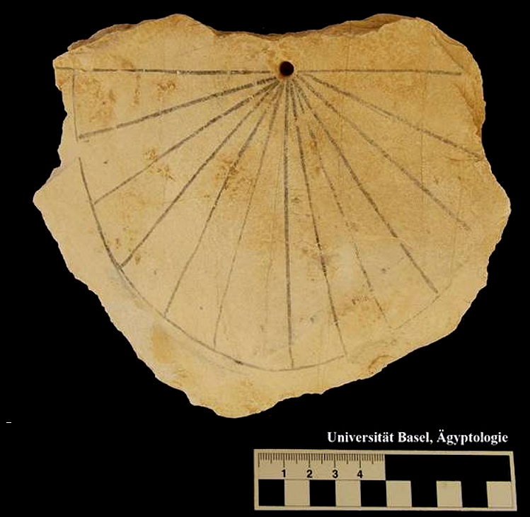 13th Century BCE Sundial [photo Courtesy University of Basel]Professor Dr. Susanne Bickel and her archeological team from the University of Basel found one of the oldest sundials in the world during this year’s excavation in the Valley of the Kings. A limestone sundial was found near tomb KV61 during a survey of the surface rubble. The location of the dial corresponds to an area where there are remains of workmen’s huts dating to the Ramesside Period of the 13th century BCE.
The dial was most likely a vertical, south facing sundial. The horizon line of the dial is about 16 cm across with a hole at the mid point to hold a simple horizontal metal rod or wood stick gnomon, indicating that the gnomon displayed shadows of temporal (seasonally uneven) hours. The limestone dial has a black painted semicircle. On each side of the vertical noon line are 6 segments of about 15 degrees each, representing morning and afternoon temporal (seasonally uneven) hours. Small dots in the middle of each hourly segment serve for even finer timing. Nevertheless, the hour lines are not drawn with precision.
The archeologists speculate that since the subdivision of the solar cycle in hours was a key aspect of depictions on the walls of the royal tombs where illustrated texts describe the nightly journey of the sun god through the underworld, the sundial could have supported the observations and visualization of this journey. Or the sundial could have been used as a simple clock by the workmen that toiled away digging and decorating the Ramesside tombs.
Read more at: University of Basel News Release 14 March, 2013
The details of the 2013 season excavation and survey for the University of Basel archeologists are found in their in Preliminary Report on the Work Carried Out During the Season 2013: Univ. Basel - Valley of the Kings Preliminary Report 2013
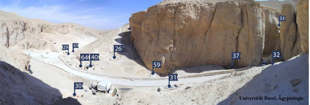 Valley of the Kings [photo Courtesy University of Basel]About 30m from KV64, a tomb of the 18th Dynasty, is KV 61 a single-room tomb that probably was never used. Near the site the limestone shard sundial was discovered. Here are extracts from the Preliminary Report:
“In preparation for the reopening and investigation of KV 61, part of the area above this tomb and in between KV 61 and KV 29 was cleared. On the east side of KV 61 the slope of the hill consists of a high heap of limestone debris, probably coming from the excavations of H. Carter and Th. Davis. This area must have been originally occupied by workmen’s huts in the Ramesside Period [so-called after the eleven kings who took the name Ramesses (1292-1069 BC)]. The back wall of a hut, which was partly discovered already in 2012, was found in this season. On the hill slope behind the hut were a few remains of wooden fragments with hieroglyphic inscriptions mentioning the name of king Amenhotep III."
“Some pottery originating from the huts as well as shards belonging to some funerary equipment were found in the area East of the hut and to the North of KV 29. Several limestone fragments of ostraca were found under a clean layer of sand and limestone chips inside the hut but also behind its wall in the East. A particularly interesting piece is an ancient sundial, which appears to be one of the oldest of its kind.”
"The remains of the huts will be included to the topographical map in the coming season. Further huts have probably been removed during the discovery of KV 61 in 1910 by E. H. Jones, who was working for Th. Davis. Today some big stones, similar to the discovered walls, are visible in the modern debris above KV 61. Our clearing of the area between KV 29 and KV 61 is done in order to secure the tombs and to prepare the entrance of KV 61 for an iron door in the coming season."
"We would like to express our sincere thanks to the Minister of State for Antiquities Dr. Mohamed Ibrahim and the Secretary General Adel Abd el-Satar, to the Director of Foreign Missions Dr. Mohamed Ismail Khaled, to the General Director of the Antiquities of Egypt Dr. Mohamed el-Bialy, to the Director of Luxor Mr. Mansour Boreik and to the Inspectorate of Western Thebes and its General Director Dr. Mohamed Abd El-Aziz, to the Director of the Westbank Mr. Nour Abd El-Ghaffar, to the Director of the Valley of the Kings Mr. Aiman Mohamed Ibrahim and Inspector Mr. Mahmud Hosni, to the Director of the Carter museum magazine Yahya Abdel Aal and Inspector Said Mamduh for their helpful cooperation, assistance and advice during our working season."
For even more about the tombs in the Valley of the Kings, see American Univ in Cairo - Theban Mapping Project
- Details
- Hits: 23176