|
|
Fort Union
|
Sundial: 393
|
| State/Province: New Mexico |
Country: USA |
| Dial Type: Compound Dial |
Condition: Poor |
| |
Latitude and Longitude: |
35° 54.497' N 105° 0.900' W |
| Location: |
- Fort Union is 8 miles north of I-25 at the end of NM 161. Watrous, NM is 1/2 mile south. Dial is located on parade grounds opposite Quartermaster's Quarters.
|
| |
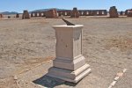
| Description: |
- A 2 foot square stone horizontal dial on a four foot high stone pedestal with vertical dials on its faces. This dial has been removed, replaced and relocated several times. The original gnomon was lost and replaced with an incorrect 45° gnomon, which has been replaced again with a steel gnomon that appears to be at slightly less than the correct latitude angle. All vertical dial gnomons are missing. The dial and a nearby inscribed stone are on the grounds of the Third Fort Union (1863-1891). The stone dial surfaces are worn from weather, but the Arabic hour numerals are still visible.
|
| |
General Information: | Inscription: | - Owner: National Park Service
| - On a stone block about 10 feet away from the dial on one side reads: "U.S. MERIDIAN AND LATTITUDE MARK EXPLORATIONS WEST OF THE --0th MERIDIAN WAR DEPARTMENT" and on the other side reads: "LONG (blank) LAT (blank) U.S. ENGINEERS 1871"
|
|
|
- Construction Date: c.a. 1871
|
| |
|
|
Last Revised: 7/23/2011 11:20